


1942 World War Map
By: Stanley Turner
Date: 1942 (printed) Toronto
Dimensions: 20.25 x 26.5 inches (51.5 x 67.3 cm)
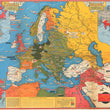
An alluring and detailed pictorial map showing a concise history of World War II up until 1942. The map presents a chronological history of the war through color-coded labels and cartoon graphics. Turner's War Maps are a stunning example of wartime cartography and pictorial mapmaking.
Taking up the vast majority of the map is Europe. Countries are color-coded based on military control: British (red) and the Axis Powers (dark green), as well as those conquered by the Axis (light green). Also shown are neutral countries in white, and in yellow, the parts of the Soviet Union not under Axis control.
Throughout the map are small illustrations detailing events of the war where they took place, with the labels for the events color-coded to identify the year in which they took place. “Evacuation of Dunkirk June 3,” for example, is coded red to signify 1940. In the lower left corner is a map of the African continent; in the upper left corner is a map of North and South America; and in the upper right corner is a map of Asia with the title cartouche “Part of the Eastern Hemisphere.” The verso offers a similar, uncolored map presenting the Pacific Theatre of War during 1942 with important events noted throughout.
This map is a fascinating example of World War II mapmaking, as well as mapmaking for the dual purposes of education and advertising.
Condition: Map is in B+ condition, with rich coloring. Issued folded with creases noticeable. A minor separation that have been repaired on the verso are apparent.
Inventory #12167
1200 W. 35th Street #425 Chicago, IL 60609 | P: (312) 496 - 3622