


1854 New Map of that Portion of North America exhibiting the United States and Territories,...
New Map of that portion of North America exhibiting the United States and Territories, the Canadas, New Brunswick, Nova Scotia and Mexico, also, Central America and The West India Islands.
By: Jacob Monk
Date: 1854 (dated) Baltimore
Dimensions: 55 x 59 inches (140 x 150 cm)
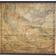
A grandiose wall map of North America produced in the mid-19th century that accurately portrays the extent of the United States soon after the Mexican-American War and the discovery of gold in California and before the outbreak of the Civil War.
Produced by Jacob Monk out of Baltimore, Maryland in 1854, this map presents a United States that is well settled east of the Mississippi and developing rapidly along the Pacific Coast, especially with regards to Bay Area and Gold Region of California, which is specifically identified within the newest state to join the Union. It also shows the vast distance between these two regions that is wholly occupied by numerous Native American tribes throughout.
At the time, easterners had the choice to reach California by sea, which would take them all the way around South America through the Strait of Magellan before the long voyage north through Golden Gate, or by land across the great plains, through the Rocky Mountains, and along the Columbia River or through the Great Basin of the Utah Territory, facing innumerable dangers along the way. Several routes from past expeditions as well as the Oregon Trail are delineated in the west, with annotations regarding tribal hunting grounds and potential shortcuts (some given the availability of water) found in several places.
From the 1850s into the 1860s the political borders of the entire western half of the United States was in a constant state of change. In this map New Mexico, Nebraska, Kansas, Utah, Oregon, and Washington are all territories and would eventually be divided up to make way for their statehood as well as the eventual statehood of North and South Dakota, Montana, Colorado, Wyoming, Idaho, Arizona, and Nevada.
The timing of this map comes during the same year as the Gadsden Purchase that would define the border between Mexico and the United States along present-day Arizona and New Mexico. An earlier proposal of this boundary that would not come to fruition is show in the map running Southwest through Chihuahua and part of Sonora before turning Northwest in Sonora to the Northern part of the Gulf of California.
Also included within the map is a "New Map of the World on Mercator's Projection," and an extensive table of the names of counties and the county towns within the United States. The map extends South to include all of Mexico and Central America with a small portion of Grenada (present-day Colombia) shown in the lower right corner.
Condition: This map is in B condition, with damp staining along the left side of the map that is mostly confined to Pacific ocean and the world map inset. A few areas of missing paper can be found in the lower portion of the map where much of the damage exists.
Inventory #11575
1200 W. 35th Street #425 Chicago, IL 60609 | P: (312) 496 - 3622