


1783 / 1963 A New and Correct Map of the United States of North America
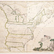
A New and Correct Map of the United States of North America Layd Down from the Latest Observations and Best Authorities Agreeable to the Peace of 1783. Humbly Inscribed to his Excellency the Governor and Company of the State of Connecticut By their Most Obedient and Very Humble Servant Abel Buell
By: Abel Buell / The Meridian Gravure Company
Date: 1783 / 1963 (copyright) Meriden, CT
Dimensions: 43.75 x 49.25 inches (111 x 74.25 cm)
This is a superb facsimile reprint of Abel Buell's most important map of the United States of America. Published by the New Jersey Historical Society in 1963, this map offers the opportunity to own a primary source reproduction of the first map of the United States published in America that famously sold in 2010 by Christie's for $2,098,500.
The map depicts the new United States and parts of Canada. Georgia, the Carolinas, Virginia, and Pennsylvania extend to the Mississippi River. Connecticut is shown with its western boundary being that of the Mississippi, thus extending through parts of present-day Pennsylvania, New York, Ohio, Indiana, and Illinois. A portion of Louisiana Territory is detailed beyond the Mississippi, and Arkansas and Osage land named as well. Extensive notes appear in the west, especially on the top left sheet. In Canada, the Bounds of Hudson's Bay by the Treaty of Utrecht is delineated.
The title cartouche in the lower right is quite decorative and features Lady Liberty sitting beneath a tree with the inscription INDEPENDENCE JULY IV MDCCLXXVI (July 4th, 1776). Above, we find an angel bowing a horn in the direction of the first American flag with thirteen stars and stripes. This cartouche is acclaimed for being the first instance an American flag appeared on a map.
Condition: This map is in A condition, issued in four separate sheets that have been professionally joined.
Inventory #12625
1200 W. 35th Street #425 Chicago, IL 60609 | P: (312) 496 - 3622