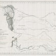


1845 Map Showing the Route Pursued by the Exploring Expedition to New Mexico and the Southern Rocky Mountains
DESCRIPTION
This is a historically important and informative map of the central plains and southern Rockies created under the direction of Captain J.C. Frémont, U.S. Topographical Engineers, and conducted by Lieut. W.A. Abert, with assistance from Lieut. W.G. Peck, was produced in 1845. It was published in Washington D.C. as part of Senate Doc No.438, 29th Congress, 1st Session.
The map was produced during Captain John C. Frémont’s exploratory missions, which were part of a larger movement by the U.S. government to map and open the western frontier for settlement. These explorations took place within the context of Manifest Destiny, the belief that the U.S. was destined to expand its territory across the North American continent. This map, created just a few years before the Mexican-American War, reflects the growing interest in the west and the Southern Rocky Mountains, as the U.S. sought to assess the region for settlement and potential resources.
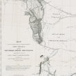
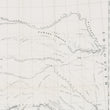
The region presented in the map covers a vast expanse of America, including present-day New Mexico, Colorado, and portions of the Central Plains now known as Kansas, Nebraska, and Missouri. The Southern Rocky Mountains are featured prominently, with the map showing various mountain ranges, rivers, and valleys in the region. Specific landmarks include the Sweetwater Mountains in the north and Santa Fe in the southern portion of the map. The Arkansas River is another central feature, flowing through the map and acting as a guide for both exploration routes and native migration patterns.
Indigenous Tribes of the Central Plains and Southern Rockies
A distinctive aspect of the map is the recognition of Native American territories, with clear boundaries for several tribes. The Sioux are shown occupying lands near the Platte River in the northern plains. To the west, the Arapaho and Cheyenne are located along the eastern foothills of the Rocky Mountains. The Pawnee are depicted near the Platte River and Missouri River areas, while in the southern plains, the Comanche and Kiowa claim vast lands near the Llano Estacado and Arkansas River.
The central plains, shown on the map, were becoming a crucial corridor for settlers traveling west along routes such as the Santa Fe Trail and the Oregon Trail. The U.S. government's growing involvement in these territories often brought it into conflict with Native American tribes, whose lands are clearly marked on the map. Despite this recognition of indigenous lands, the pressures of U.S. military expansion and settler migration would soon result in the displacement of many tribes.
Crucial Frontier Forts and Outposts
The map highlights several key landmarks and forts that played significant roles in the mid-19th century American West. One notable landmark is Fort Laramie, located near the northern part of the map along the Platte River. Originally established in 1834 as a fur trading post, it became a crucial military outpost for the U.S. Army in 1849, serving as a hub for settlers traveling along the Oregon Trail and later as a center of operations during conflicts with Native American tribes. The map also features Fort Leavenworth, situated on the Missouri River in present-day Kansas. Established in 1827, Fort Leavenworth was the oldest permanent settlement in Kansas and a major military post that protected westward migration and trade routes.
CONDITION
1200 W. 35th Street #425 Chicago, IL 60609 | P: (312) 496 - 3622


