


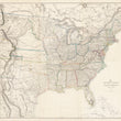
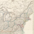
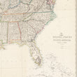
1859 United States of North America (Eastern & Central)
DESCRIPTION
By: Theodore Ettling
Date: 1859 (circa) London
Dimensions: 34 x 35.75 inches (86 x 90 cm)
This is a scarce six sheet map of the United States just prior to the Civil War and in this midst of Westward Expansion. The map made by Theodore Ettling and published by Day and Son Lithography based in London, circa 1859.
The map is rich with detail including towns, cities, roads, and early American railroads, most of which can be found in the northern states and would prove to be a major advantage for the Union Army throughout the Civil War. All state boundaries are as they appear today with the exception of Virginia, which has yet go through the succession of West Virginia that would officially be recognized as a state on June 20, 1863.
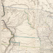
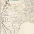
The Western Frontier of North America
Just west of the Mississippi, we find the expanding western frontier early settlements and all proposed routes for potential trans-continental railroads that had just been surveyed in the years that preceded the publication of this map. Many indigenous tribes are noted throughout this portion of the map and they are of great importance as a series of conflicts from the early 1850s through the late 1870s between the Native Americans and the United States would later be recounted as the Plains Indian Wars.
The territories themselves were also ever-changing on maps and their configuration help us date this map. Minnesota is in its largest form and the western half of the state is recognized as Yankton County, following the Yankton Treaty of 1858 that ceded Sioux lands east of the Missouri to the United States. Additional territories include Indian Territory (Oklahoma) Kansas, Nebraska, Washington, Oregon, Utah, New Mexico, and an early emergence of the Arizona Territory. The Colorado Territory would be added to the map in 1861.
An overall superb map for any enthusiast of westward expansion, American history, often found in six separate sheets, we have taken the expense of joining them for immediate enjoyment and potential framing.
Condition: This map is in A condition, with bright color on clean paper, printed on six sheets that have been professionally joined.
Inventory #12626
1932 S. Halsted #200 Chicago, IL 60608 (312) 496-3622
CONDITION
1200 W. 35th Street #425 Chicago, IL 60609 | P: (312) 496 - 3622