


1861 Map of Cook County, Illinois
By: W.L. Flower
Date: 1861 (dated) Chicago
Dimensions: 6 ' X 5 ' 3 "
Rare pre-fire wall map of Cook County and Chicago, IL. Less than ten known examples, most of which reside in institutions and will not be offered again fr public sale.
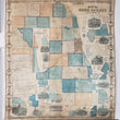
This is a large wall map of Cook County, done in 1861 by J.W. Flower. The map was published by S.H. Burhans & J. Van Vechten. It was engraved, printed, colored, and originally mounted by Edward Mendel who was a famous Chicago based (162 W. Lake st.) lithographer and engraver known for his currency designs and early Chicago prints. The map is colored and includes a reference key for railroads, canals, wagon roads, churches, houses, and a complete list of Cook County post offices.
The map includes over 30 inserts of various towns throughout Cook county as well as a business directory list for many of the towns. A large number of the towns in this map have since been unincorporated, renamed, or incorporated into the city of Chicago. For example, the town of Long John and Minnehaha no longer exist. The town of Taylorsport is now known as Glencoe, Brickton is now Park Ridge, and Dunton is now Arlington Heights. Pine Grove is now part of the Lakeview neighborhood of Chicago and Jefferson, once a small settlement of traders, hunters, and farmers, is now a densely populated neighborhood of Chicago known as Jefferson Park. Images of important buildings and places decorate this map throughout. Some of these images include the Women's College of Northwestern, Bryan Hall, the Tremont House, Graceland cemetery, and a view of the city from the lakefront.
Surrounding the map is a floral vignette border containing twenty advertisements for businesses throughout the cook county some of which include apothecaries, horse veterinarians, brewers, and a horse boarding and sales stable. Numerous historical features are displayed throughout this map. Just to the north and south of the Chicago are two lines running diagonally from the lake to the southwest of the map. These lines are the start of large Indian boundary lines that run deep into the state of Illinois. These lines came about in 1816 when the Sauk and Fox tribes ceded land within a 20 mile corridor to the U.S. at the Treaty of St. Louis. The land outside the boundary lines was owned by the Native American tribes until the Chicago treaty in 1833. Another interesting historical marker found in the map is the Tomb of Stephen A. Douglas which lies just south of Cottage Grove. Soon after this map was made, the land around the tomb became the site of a Union Army volunteer training center that thousands of Chicago area recruits would soon pass through. As the war went on, the training center became a Confederate Soldier prison camp that came to be known as Camp Douglas.
The fact that there are less than 7 examples of this map in current, recorded existence makes this piece a rarity in its truest form. All examples of this map except one are held in various institutions including the Library of Congress, Chicago Historical society and the Newberry Library. This is the first example of the 1861 Cook County Map by W.L. Flower to ever be offered for public sale.
Condition: B with original color except in the areas of restoration where original paper was missing. The map has been professionally restored with a new canvas backing and wood mounts making it ready for immediate display in any home, office, or lobby.
Inventory #18071
1200 W. 35th Street #425 Chicago, IL 60609 | P: (312) 496 - 3622