

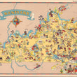

1935 Kentucky
By: Ruth Taylor White
Date: 1935 (published Boston)
Dimensions: 12.5 x 9.25 inches (31 x 23 cm)
This colorful vintage map of Kentucky from 1935, has a Compass Rose depicting a stereotypical Jockey with his race horse. It accurately shows where the three rivers meet to become the mighty Mississippi. Daniel Boone was the first to explore this region, as he led an party over the Cumberland Mountains from North Carolina. In addition to her famous race horses, Kentucky farms produce tobacco, wheat, corn, hay, hogs, & cattle. Among its natural wonders are, the Mammoth Cave & the Colossal Cavern. During the Civil War, the state was divided.
Note: Image of map description is not on the verso of this map.
Condition: A condition with full margins, clean paper, & vibrant colors.
Inventory: #17168
1932 S. Halsted St. #200 Chicago, IL 60608 P: (312) 496-3622