


1927 Chicago's Gangland
By: Frederic M. Thrasher
Date: 1927 (published) Chicago
Dimensions: 25.5 x 17.5 inches (65 x 44.5 cm)
A very fine example of an iconic thematic map of Chicago, of which its subject matter, gang activity, is synonymous with its century-old reputation as a city of organized crime. Thrasher's map was published within his book The Gang: A Study of 1,313 Gangs in Chicago in which Thrasher takes a deep dive into not only the prolific mobs of Al "Scarface" Capone, George "Bugs" Moran, and Dean O'Banion, but the younger, second-generation immigrant gangs that were coming into their own in the age of prohibition and bootlegging.
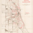
The base layer of the map is similar to many other maps of Chicago with regards to the area shown and the depiction of street and boulevards. It spans from 95th street to Bryn Mawr Avenue and the lakefront to Austin Avenue. A legend distinguishes between railroad property, industrial property, parks, boulevards, and cemeteries in different shades / patterns of grey. Gangs with clubrooms vs. gangs without clubrooms are identified by red circles or triangles, an important distinction during the Era of Prohibition.
Nicknames of various neighborhoods and points of the city that are both widely recognized as well as made up by Thrasher are given in red. Such areas include the Gold Coast, Hotel Coast, Back-of-the-Yards, China Town (old and new), Goose Island, and the Polish-Jewish Frontier to name a few. High concentrations of Chicago's wide array of ethnic groups are also noted in grey with the approximate boundaries of their territories encircled. Some of these ethnic groups include Jewish, Black, Italian, Dutch, Polish, German, Hungarian, and Ukrainian.
According to Frederic Thrasher:
The map illustrates "the most important conclusion suggested by a study of the location and distribution" of Chicago gangs: that Gangland isn't only a matter of geography, but of "socially interstitial" areas of the city, places where there are "fissures and breaks in the structure of social organization." (p.22, Thrasher)
Additionally, what Thrasher argues and presents in this thematic map of Chicago, is that gangs develop and thrive in the “interstices” between ethnic, racial and religious communities and industrial and residential zones. His layers of data between gang locations and their activity over the map of Chicago gives geographic credence to his theory.
Ref: PJ Mode Persuasive Map Collection
Condition: This map is in A condition, with bright red color and full margins on all sides. Issued folded and on thin paper, the map has professionally linen-backed for preservation and presentation purposes.
NOTE: The map appears more tan in-person when compared to its appearance on our website.
Inventory #12620
1200 W. 35th Street #425 Chicago, IL 60609 | P: (312) 496 - 3622