


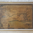


1932 Map of Chicago about 1833
By: Walter Conley & O.E. Stelzer
Date: 1932 (dated) Chicago
Dimensions: 29.5 x 40 inches (75 x 101.5 cm)
A fine example of the rare first state of Walter Conley's "Map of Chicago about 1833," which was created to commemorate the centennial anniversary of the incorporation of Chicago as a town with a population of roughly 350 residents on August 5, 1833.
Examining the Map / Bird's Eye View
The map offers a window into the early days of Chicago with just twenty blocks laid just south of the main branch of the Chicago River. Some of the city's earliest schools, churches, and establishments are noted including Sam Miller's Public House, Hubbard's Warehouse, the Sauganash Tavern, Wolfe Tavern, Dr. Wolcott, and of course the 2nd Fort Dearborn to name a few. The river is shown in its most natural state, save for the direct channel to Lake Michigan cut by soldiers in 1833. A total of eleven views and scenes fill what would be empty space with imagery of what one would see if they were walking about the town in the early decades of the 19th century.
The descriptive title cartouche can be found in the lower left portion of the map with a white settler and Native American standing, facing each other on either side. The lower portion of the border features three panels that offer the early history of Chicago, including the arrival of Louis Joliet and Father Marquette in 1673, the orders to build Fort Dearborn in 1804, and the uprising of local natives in 1812 that lead to the massacre on August 15th when 50 soldiers fought helplessly against 500 native warriors.
The three other sides of the border hold an additional title written in Latin that roughly translates to Chicago in the year 1833 Description with pictures from historical documents now originally opened in an ancient way.
Making the Map
Walter Conley (1893 - 1936) was a successful Chicago architect who is best known for the one map he created. The research period required to put together this map lasted roughly two years. During that time Conley commissioned the help of Caroline M'Ilvaine of the Chicago Historical Society to procure documents, sketches, and any other relevant historical material. Once his research was complete, Conley hired the Swiss-German artist Otto Emil Stelzer to draw up his design and had 100 large prints produced, each of which he signed and numbered and sold for $100, which is equivalent to about $3,300 today.
He then produced 500 copies of a smaller, simplified edition that omits the horizon, elaborate border, several scenes and lesser noteworthy landmarks. Finally, a third and even slightly smaller edition was made in greater number to be sold to the general public. This final version was also published in color in the Chicago Sunday Tribune of August 13, 1933.
Scarcity of the Piece
This work was part of a limited run of 100 copies that were made for the Century of Progress World's Fair. We are aware of just five other examples of this work, three of which reside in the Chicago Historical Society, one uncolored example held by Pennsylvania State University Libraries, and that we sold to a private collector in 2021.
Condition: This map is in B condition. It was dry-mounted onto a thick and sturdy backing board and varnished as was common practice during the 1930s. Somewhat darkened with age but retains pleasing eye-appeal.
Inventory #12313
1200 W. 35th Street #425 Chicago, IL 60609 | P: (312) 496 - 3622