


1861 Johnson's New York
DESCRIPTION
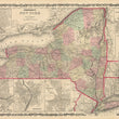
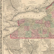
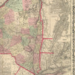
This is an original antique map of New York State published by Johnson and Browning out of New York in 1861. The map is color coded by county with townships also identified and shows railroads, wagon roads, rivers, canals, ports, large towns, and villages of the mid-19th century. Several smaller inset maps include the vicinity of New York, Troy, Albany, Oswego, Buffalo, Rochester, and Syracuse.
CONDITION
This map is in A condition with bold original color on fine paper with ample margins on all sides. Some light paper toning is apparent along the outer margins.
1200 W. 35th Street #425 Chicago, IL 60609 | P: (312) 496 - 3622