


1935 Rhode Island
By: Ruth Taylor White
Date: 1935 (published) Boston
Dimensions: 8.5 x 11.5 inches (22.2 cm x 29cm)
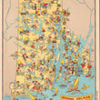
This is an antique map of Rhode Island by Ruth Taylor White, featured in her landmark pictorial atlas Our U.S. A Gay Geography, published out of Boston in 1935.
The map is a lively portrayal of the smallest state in our Union. Known for textile mills and Narragansett Bay, Rhode Island offers the best of both worlds - the new and the old. The Bay provides safe harbors for commerce, while the waters yield fish, oysters, clams, & lobsters. The variety of goods this tiny state provides is surprising. From the farms come hay, corn, oats, potatoes, etc. Rhode Island made the first declaration of complete religious liberty in America.
Note: Image of map description is not on the verso of this map.
Condition: Map is in A condition with no tears, holes, or staining.
Inventory #17156
1200 W. 35th Street #425 Chicago, IL 60609 | P: (312) 496 - 3622