


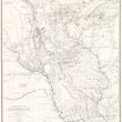


1843 Hydrographical Basin of the Upper Mississippi River
Hydrographical Basin of the Upper Mississippi River from Astronomical and Barometrical Observations Surveys and Information, by J.N. Nicollet in the years 1836, 37, 38 and 40 assisted 1838, 39 & 40 by Lieut. J.C. Fremont
By: Joseph N. Nicollet / William H. Emory
Date: 1843 (dated) New York
Dimensions: 36.25 x 30.25 inches (92 x 77 cm)
This is an exceptional example of the first map to accurately depict the the northern reaches of the Mississippi River and its source. The map was not only groundbreaking in its geographic depiction of what was then a largely unknown region of the Northwest Territory, but the scientific methods employed forever changed the way future expeditions into the American West would be conducted.
The map covers much of present day Missouri, Iowa, Wisconsin, Nebraska, Minnesota, and the Dakotas up to the Canadian border. The map is a compilation of three expeditions led by Nicollet from 1836-1839 that employed some of the most tedious scientific procedures ever conducted in unknown lands. Well over a hundred asterisks can be found throughout the map noting the exact location where astronomical observations were conducted. While determining longitude and latitude was nothing new for the time, Nicollet measured barometric pressure to help determine altitude. While this method is not entirely accurate as barometric pressure can change with the weather, it was regarded as a ground breaking technique that would be employed in many expeditions years later, from Fremont's monumental explorations of the Western States (1842-44), to Powell's expedition of the Colorado River and Grand Canyon (1871).
While the expedition and map was done with a focus on hydrography it also includes updated topographic detail as well as the general locations of a dozen Native American tribes, including the Sac & Fox, Winebago, Chipeway, Pawnee, Otoe, Iowa, Omaha, and the eastern Sioux bands of M'dewkanton, and Yankton to name a few. Further detail is given to the various hunting grounds of these tribes, and the phonetics of their language (in a NOTE above the title). It should also be noted that Nicollet documented many aboriginal names used for rivers, lakes, valleys, etc. many of which are still in use today on account of this map.
Many of these tribes would be removed from their land prior to the Civil War and then return during the war when the Federal Government and military leaders were fighting back east, By then a lot of Anglo-European immigrants and settled in the area and horrific violence (the likes of which had never been seen by these Europeans) ensued as the Native Americans fought to reclaim their aboriginal lands. Soon after word had reached Washington, the military was sent back out to force the natives back onto reservations in present day Oklahoma.
Joseph Nicollet (1786 - 1843) was a French geographer, astronomer, and mathematician who is most recognized for the expedition that led to this very map of the Upper Mississippi. Prior immigrating to America in 1832, Nicollet was a professor of mathematics at Collège Louis-le-Grand, and a professor and astronomer at the Paris Observatory. His maps were regarded as the most accurate works of the time, correcting errors by earlier cartographers including Zebulon Pike. Though he died just prior to the publication of this map, his influence lived on for decades through some of the most important expeditions and maps of 19th century American exploration.
Condition: Map is in A+ condition, very clean and bright with only a few areas of light foxing. It has been linen backed and presents beautifully with the necessary durability for extensive, up-close study. The map is accompanied by the full report of the expedition with original binding and covers lightly worn and some scattered foxing throughout the pages.
Inventory #11996
1200 W. 35th Street #425 Chicago, IL 60609 | P: (312) 496 - 3622