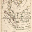


1700 Le Royaume de Siam Avec les Royaumes qui luy sont Tributaires et les Isles de Sumatra, Andemaon, etc. et les Isles Voisine...
By: Pierre Mortier
Date: 1700 (circa) Amsterdam
Dimensions: 31 x 22 inches (78.7 cm x 55.9 cm)
This is a lovely full color example of Pierre Mortier's map of Southeast Asia, including the Kingdom of Siam and other territories. This remarkable map was one of the largest and most detailed maps of this region to appear in the early 18th century.
The map covers much of Southeast Asia and the East Indies including modern day Thailand, South Vietnam, Cambodia, Malaysia, Singapore, Borneo, Sumatra and Java. It also offers wonderful detail of the Andaman Islands, the Gulf of Thailand (Golfe de Siam) and coastal Vietnam. Navigable inland river systems, are also depicted, particularly the Mekong and the Chao Phraya. In the Kingdom of Siam, the map shows the fortress of Bangkok, the ancient Siamese capital of Ayutthaya, royal palace, and the Dutch trading colony.
In Cambodia, it details the village of Ponompingn (Phnom Penh), Lewek on Camodia, and the Dutch trading mission. In the seas this map offers numerous depth soundings and shows the trade routes between Batavia (Jakarta, Java) and Siam (Thailand) and details the shoals and reefs off the coast of modern day Vietnam. Mountain regions are shown pictorially.
The bottom map details the southern parts of the Malay Peninsula, Sumatra, Borneo and Java focusing on the Straits of Singapore (Cingapura). Numerous forts, trade missions, and settlements are depicted. The trade routes between Siam and Batavia are illustrated along with some of the hazards of the Straits of Cingapura (Singapore).
Condition: This large map is in excellent condition with original hand color over clean and sturdy paper. Full margins frame the map image on all sides.
Inventory #11150
1200 W. 35th St. #425 Chicago, IL 60609 | P: (312) 496 - 3622


