


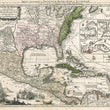


1750 Mappa Geographica Regionem Mexicanam et Floridam…
Mappa Geographica, Regionem Mexicanam Et Floridam Terrasque adjacentes, ut et Anteriores Americae Insulas, Cursus itidem et Reitus Navigantium versus flumem Missisipi et alias Colonias ob oculos ponens cura et sumtibus
By: Matthaus Seutter / Conrad Lotter
Date: 1750 (circa) Augsburg
Dimensions: 19.5 x 22.75 inches (50 cm x 57.8 cm)
This beautiful map is Seutter’s decorative version of Delisle’e important map Carte de Mexique et de la Floride of 1703, engraved by Seutter’s son-in-law, Conrad Lotter, who took over the business on the death of Matthaus Seutter.
Colonial Claims in North America
The region has been engraved and colored to present the colonial boundaries as dictated by the Treaty of Utrecht in 1713. The area to the east of the Appalachian Mountains contains the British colonies, while France lays claim to the Mississippi valley and Florida (which covers much territory). The details of the Mississippi Valley represent a radical departure from earlier maps as they accurately depict the information provided by the French Jesuits in North America in the late seventeenth century.
Mexico and much of Central America down to Panama is labeled ‘Nova Hispania’ as the Spanish controlled this vast stretch of land as far north New Mexico. Many native tribes and their pueblos are included in the territory of New Mexico including Acoma, Santa Clara, Isleta and more. The areas along the Rio Grande and in Texas are minutely detailed, and there is rich annotation regarding Spanish activities in the Gulf of Mexico.
Maritime Trade, Plunder, and Piracy in Caribbean
In the top right portion of the map four inset plans show the important trade centers of Vera Cruz, Cartagena, Havana and Panama. Sea Routes are delineated in a way that shows how exploited riches in New Spain were transported to Havana where they would then be transferred to trans-Atlantic Galleons that would sail through the Bahama Canal in route to Spain. It was this region where ships were always on guard for Pirates attempting to run aground the large vessels and plunder their booty.
To help illustrate the ongoing maritime conflicts within the region, the lower left quadrant depicts a huge conflagration at sea, with countless ships in various states of repair/disrepair, cannons blasting and smoke billowing. Lifeboats full of men are seen racing toward the shore. All the while, merchants load trunks and barrels on shore while onlookers gaze upon the chaos with a spyglass.
Condition: This map is in B+ condition with original color over a dark impression and full margins on all sides. An centerfold separation in the top and bottom has an old, but proper repair on the verso. The lower portion of the map shows signs of damp staining, which is most noticeable in the lower center but does not distract from the map as it blends well with the rest of the paper.
Inventory #12319
1200 W. 35th Street #425 Chicago, IL 60609 | P: (312) 496 - 3622