


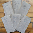
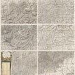
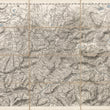
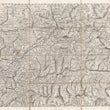
1802 Tyrol
DESCRIPTION
Dimensions: 16 x 22.25 inches (40.6 x 56.5 cm) Each Sheet
64 x 44.5 inches (162.5 x 56.5 cm) Combined
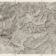
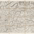
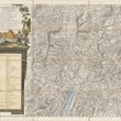
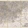
A magnificent set of six linen-backed folding maps presenting the broad region of the Tyrol located in the German / Italian Alps. The maps are identical in size and each is numbered by plate from 1-6 . They are highly detailed with an extensive legend in the lower left to aide varied content of the map. The rugged terrain is rendered beautifully with hachure and all rivers and lakes are colored blue and stand out amongst the sharp print impression of each map.
Tyrol, situated in the Alps of Northern Italy and western Austria, holds a rich historical legacy. Serving as the central region of the County of Tyrol, it played a significant role within the Holy Roman Empire, the Austrian Empire, and Austria-Hungary from its establishment in the 12th century until the conclusion of World War I in 1919.
CONDITION
1200 W. 35th Street #425 Chicago, IL 60609 | P: (312) 496 - 3622