


1574 Tabula Europae IIII
By: Girolamo Ruscelli
Date: 1574 (published) Venice
Dimensions: 7.25 x 10.25 inches (18.4 x 26 cm)
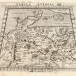
This highly desirable Ruscelli map in trapezoid form is from his work La Geografia di Claudio Tolomeo Alessandrino. Based on the works of Claudius Ptolemy and the atlas of Giacomo Gastaldi, it features northern and central Europe including a vast region labeled as Germany, plus Poland and Denmark, the Low Countries. A number of islands in the Baltic Sea and a portion of both the north and south shorelines of the Baltic are depicted. The map’s southern boundary is marked by the Danube. Mountain ranges include, among others, the Alps and the Carpathians.
Julius Caesar’s description of the unconquered region east of the Rhine River as Germania is the first known reference to depict it as a distinct region in central Europe, thus distinguishing it from Gaul, which he had already conquered. After the fall of the Roman Empire the region would eventually come under the reign of regional potentates such as dukes, princes and bishops. With the collapse of the Holy Roman Empire, the modern nation-state system was instituted, dividing Germany into numerous independent states such as Bavaria, Saxony, etc.
The map is of especial interest for its depiction of flora and fauna of the region, an unusual addition to the maps of this atlas. It features a number of horned animals, including moose, bison and a third species which resembles either wild sheep or deer. A rather large bird with a long beak is also depicted. River systems and forested areas are denoted. Major cities are represented pictorially, bearing their Latin names.
Girolamo Ruscelli (1500-1566) was an Italian polymath, humanist, editor, alchemist and cartographer active in Venice during the early 16th century. Ruscelli is best known for his important revision of Ptolemy's Geographia, published posthumously in 1574.
Claudius Ptolemy (85-165 CE), a Roman citizen of Greek descent from Alexandria, was the most influential of Greek astronomers and geographers of his time. He propounded the geocentric theory of the solar system which was to prevail for the next 1400 years.
Condition: This map is in A condition. Heavily inked plated with some residue, otherwise sharp clear impression. Descriptive Italian text on the verso.
Inventory #11802
1200 W. 35th Street #425 Chicago, IL 60609 | P: (312) 496 - 3622