


1949 Sabena Airlines Timetable Map
By: Sabena Airlines
Date: April 1949 (dated) Belgium
Dimensions: 29 x 18 inches (73.5 x 45.7 cm)
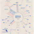
An ingenious timetable map showing the routes of Sabena and other partnered airlines out of Melsbroek Airfield in Brussels, Belgium from April to October of 1949. The offers a look at commercial air travel post WWII when the industry was just emerging as a premier method of travel.
The map centers on Brussels, the hub of Sabena with lines that vary in color and thickness radiating outward in the general direction of the destination. Most of Sabena's service is to neighboring countries such as England, Spain, France, Germany, Switzerland, and Italy to name just a few. A number of flights serve cities in North and East Africa and the Belgain Congo, which the latter was under Belgian control until the mid-1960s. Consequentially, the cities of Elizabethville, Leopoldville, and Stanleyville are known today as Lubumbashi, Kinshasa, and Kisangani respectively. The furthest destinations that once can reach from Melsbroek Airfield were Johannesburg and New York.
A set of useful keys can be found in the top-right portion of the map. Colors of the lines represent the time of year flight service is provided and the thickness indicates frequency of flights from daily to weekdays and limited frequency. Days are indicated by numbers and times of departure and arrival are given within the map in what many refer to as military time. Abbreviations for the partnered airlines that connect to Brussels are also provided and include companies like Avio Linee Italiane, British European Airways, Swissair, and Scandinavian Airlines.
In the lower left, the map is ornamented with a winged chef boast the fine dining travelers can expect in French, English, and Dutch,
Condition: This map is in B+ condition with some light staining in the top and bottom left portions of the map. Issued folded, the map has been flattened and linen-backed for preservation and presentation purposes.
Inventory #12042
1200 W. 35th Street #425 Chicago, IL 60609 | P: (312) 496 - 3622