


1949 Mapa de los Paisajes de Cuba
By: Gerardo Canet & Erwin Raisz
Date: 1949 (published) Chicago
Dimensions: 21.5 x 59 inches (54.5 x 150 cm)
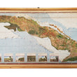
This is a rare map of Cuba that through it's method of production, advanced a relatively new method of Aerial Mapping by combining standard practices in terrain mapping (shaded slopes to illustrate relief) with photographic air imagery. The motivation behind this technique was to add a more realistic or human element to the map in that the land is colored as it was seen from above by the human eye.
In the words of Gerardo Canet and Erwin Raiz "The accompanying map of Cuba is a new experiment in cartography. Color suggests land types: cultivated fields, pastures, mountains, swamps, valleys, etc. The symbols were selected after a series of flights over the Island and on analysis of numerous color photographs taken from the air It is expected that in this way the map will better reflect reality; more closely resembling on air view of the Island than the conventional maps we now have."
Additionally the map includes eight images depicting realistic views of the various natural geographic regions of Cuba. These views include sandy savannas, mogotes, pinelands, fertile clay savannas, mangroves, forests, serpentine savannas, and Xerophiytic Vegitation (plants that survive with little water). These diverse ecological regions of Cuba play a major role in the culture, cuisine, lifestyle, and dwellings of the people that live within them, adding to the element of human geography on display in this map. A large inset of Havana can be found in the top right and an legend in the lower left identifies roads, railways, villages, airports, lighthouses, agricultural lands, the shallow sea and deep ocean.
Condition: This map is in B+ condition, in wall map form with attached wooden rollers, with a small hole in the top center.
Inventory #11512
1200 W. 35th Street #425 Chicago, IL 60609 | P: (312) 496 - 3622