


1696 / 1717 Nova Tabula Geographica Complectens Borealiorem Americae Partem
Nova Tabula Geographica Complectens Borealiorem Americae Partem... & Carte Nouvelle Contenant La Partie d'Amerique La Plus Septentrionale...
By: Nicolaes Visscher / Peter Schenk
Date: 1717 (circa) Amsterdam
Dimensions: 23.5 x 18.5 inches (Each Sheet)
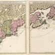
A lovely example of the third state of Visscher's two-sheet map of the Eastern Coast of North America, stretching from the mythical Lake Apalache in the Spanish controlled Florida to Newfoundland and the Grand Banks. This example was printed by Peter Schenk Jr. whose name appears at the bottom of the right sheet.
Originally printed in 1696, Visscher's map was a much needed improvement on the cartography of the Mid-Atlantic and Northeast region. It is considered a true original work as the map does not replicate the work and information of any one prior mapmaker. Improved cartographic detail can be found in the presentation of Long Island, Lake Champlain, the St. Lawrence region, and the Carolina Coastline. Much of the updated information shown in the map came from Visscher having greater access to Dutch and English sources.
There are some areas that would still need improvement, including Delaware Bay depicted too wide and of course, interior details. For example, the delineation of the St. Lawrence runs on a more Southwesterly diagonal and does not open into a large lake, which is labeled "Le Grand Sault St. Louis." Lake Ontario is shown as a single source that feeds into the St. Lawrence as opposed to the first of the chain of five great lakes. The Finger Lakes have yet to appear and Lake Seneca (present day Lake Oneida) is far too large.
The map is colored in a manner to show division between French and English colonies. Early colonial settlements that are primarily confined to the coastal regions and waterways are depicted as well as numerous Native America tribes that populate the interior.
Often times these maps are only available individually. This is a unique opportunity to obtain two matching sheets that when joined together offer an impressive visual of the best cartographic knowledge of Colonial America at the turn of the 17th century.
Condition: Maps are in B+ condition with some centerfold separation along the left sheet that has been professional repaired on the verso. Color appears to be old, but likely not original as the oxidation on the verso is rather bright for its age.
Inventory #11688
1200 W. 35th Street #425 Chicago, IL 60609 | P: (312) 496 - 3622