


1720 A Plan of the City’s of London, Westminster and Borough of Southwark...
A Plan of the City’s of London, Westminster and Borough of Southwark; with the new Additional Buildings anno 1720
By: John Senex engraved by Samuel Parker
Date: 1720 (dated) London
Dimensions: 19.75 x 23 inches (50.2 x 58.4 cm)
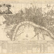
This fascinating, highly detailed map of London by John Senex, one of the leading English cartographers of the period, presents the city that was built following the Great Fire of 1666. The city is laid out in extensive detail showing New River Head, Whitechapel, Lambeth, and the Borough of Southwark with new buildings, such as St. Paul’s Cathedral, completed in 1710. The ancient city walls, which survived the fire in many places and which today may be seen in several places, are clearly shown to be very much intact.
The map includes an index which locates the 87 parishes in London and Westminster, and eight in Southwark. Many parishes had new churches built between the years 1670 and 1711, fifty-two of which were designed and executed by Christopher Wren. Samuel Parker, the engraver, did a superb job of drawing and engraving so that minute details of the city's topography are shown.
The attractive cartouche includes symbols of London's greatness: two cornucopias, one of fruit and one of precious metal objects and jewels, and the city arms and insignia, along with a scale bar. At the base is a picture of a king, presumably George I, whose sword and scepter are supported by two dragons. To the sides and behind these are symbols of British cultural and mercantile superiority. The map is dedicated to Sir Peter Delme, a wealthy and powerful individual, one of the first residents of Grosvenor Square, and for a time, Lord Mayor of the city of London.
Condition: This map is in B+ condition. Some rust spots and minor foxing.
Inventory #11504
1200 W. 35th Street #425 Chicago, IL 60609 | P: (312) 496 - 3622