


1827 Tegg's New Plan of London, &c. with 360 References to the Principal Streets
Tegg's New Plan of London, &c. with 360 References to the Principal Streets, &c. 1827.
By: Thomas Tegg
Date: 1823 / 1827 (dated) London
Dimensions: 17 x 24.5 inches (43 x 62 cm)
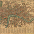
This is a fine example of an early 19th century travelers’ folding map of London with references to 260 principal streets. The map was first issued by Thomas Tegg out of London in 1823 and issued several times thereafter until the early 1830s. As specified in the title, this example was issued in 1827.
The map centers on old London nestled along the River Thames with the original boundary outlined in red. Portions of neighboring burrows such as Westminster, Camden, Southwark, and Tower Hamlets are also included within the map as the outskirts of the growing city of London. The map was issued as a sectional, folding map with 18 distinct panels that are subdivided into 20 sections, numbered accordingly throughout the map. Below the map is the complete list of 360 principal streets and the corresponding section to which they can be found.
While a map such as this is filled with wonderful historic landmarks, we would like to draw your attention to “the Queen’s Palace,” which can be found in panel #12 surrounded by the Queen’s Garden, Green Park, and St. James Park. The palace was originally intended as a private retreat for Queen Charlotte, (the wife of King George III) would become the home of Queen Victoria and forever known as Buckingham Palace, just seven years after the publication of this map. Other noteworthy historic landmarks that can be found within this map include Westminster Abbey, the London Bridge, Towers of London, and numerous churches, gardens, and squares where important events have taken place over the centuries.
Condition: The map is in B+ condition, originally issued folding with linen. Some of the folding areas have been reinforced on the verso where the linen was separated or weakened. Annotations on the verso indicate the map was given as a gift in 1829.
Inventory # 12136
1200 W. 35th Street #425 Chicago, IL 60609 | P: (312) 496 - 3622