


1625 Hondius his Map of Island
By: Jodocus Hondius
Date: 1625 (Published) London by Samuel Purchas
Dimensions: 5.25 x 7.25 inches (image) 13.34 x 18.42 cm
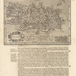
The first publication of this fascinating small Hondius map of Iceland was in the reduced version of the Mercator/Hondius ‘Atlas Minor’ of 1607. The plates were later sold to Samuel Purchas who used them for his English language publication ‘Purchas His Pilgrimes’, from which this map comes.
The map is highly detailed with cities, settlements and fortifications indicated. River systems, lakes and the many mountain ranges which cover much of Iceland are depicted and its most famous volcano, Hekla, is shown in eruption. The map is embellished with one sea monster, a lovely strap-work title cartouche, and a decorative border surrounding the distance legend. The cartography resembles that of Ortelius’ earlier, well-known map of Iceland, but is not identical to it.
Condition: The image of the map is in A condition. The entire sheet has some offsetting just below the image, and the paper is rather thin. One fold in the lower portion.
Inventory #11889
1200 W. 35th Street #425 Chicago, IL 60609 | P: (312) 496 - 3622