


1935 Louisiana
By: Ruth Taylor White
Date: 1935 (Boston)
Dimensions: 12.5 x 9.25 inches (23 x 31 cm)
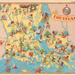
This is an entertaining and informative pictorial map of Louisiana by Ruth Taylor White from the 1930s.
Louisiana is said to have built almost half of the State from beneath the sea, by depositing silt brought from the North each year at flood time. It is often compared to the Netherlands, due to the numerous dikes. New Orleans is the most picturesque city, with a blend of French, Spanish, English, and American traditions. Low & flat, the state is crisscrossed with bayous, shallow rivers, swamps, & forests.
Within the compass rose, portrays a French chef holding a plate of food. Usual stereotypical characters from this period can be seen throughout.
Note: Image of map description is not on the verso of this map.
Condition: A condition with bright color on clean paper and full margins.
Inventory # 17165
1200 W. 35th Street #425 Chicago, IL 60609 | P: (312) 496 - 3622