


1587 / 1620 Orbis Terrae Compendiosa Descriptio Quam ex Magna Universali Mercatoris...
By: Gerard and Rumold Mercator / Published by Jodocus Hondius
Date: 1587 / 1620 (published) Amsterdam
Dimensions: 14 x 21 inches (35.5 x 53.25 cm)
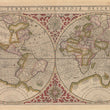
This important and influential Mercator map of the world was first printed in Geneva in 1587 while Gerard Mercator was still alive, and again in 1620 by Jodocus Hondius. It is the only obtainable version of his world maps, as both the 1538 and 1569 versions are rarities, not available on the market. The map was directly influenced by Gerard himself and is an important element in the history of cartography due to its geography and its maker. Though the map uses double-hemisphere format rather than the Mercator Projection, it is in fact a reduced version of Gerard’s 1569 wall map of the world in which he introduced his famous projection.
Australia and Tierra del Fuego are shown to be parts of an enormous southern continent, covering the entire Antarctic region, while above the Arctic Circle are four large islands which Gerard believed existed. In the open waters to the west of North America the Straits of Anian are noted, and the northwest region of the continent is named in Latin Anian Regnum, the Kingdom of Anian.
The St. Lawrence Seaway is named, and depicted with remarkable accuracy, suggesting Mercator’s familiarity with the geographic discoveries of Jacques Cartier. Florida is shown and named, and California is depicted more accurately than it would be at a later date. Cuba, Central America and the entire area of the Gulf of Mexico are quite accurately delineated, as are the Appalachian Mountains. A small river system which could represent the Mississippi is shown.
The bulge of South America which Gerard introduced in his 1569 map is still depicted, despite the rather more accurate Gastaldi map of 1568. The Amazon River and the Rio de la Plata are both present, and many places in South America are named and charted, including settlements, ports and cities.
The Eastern Hemisphere in general is quite accurately depicted, due to the extensive charting done by early explorers. The forms of the continents and many islands resemble modern day satellite images, Japan being an exception as it is represented as a large rectangle with rounded corners. Many place names throughout the map have changed little and are identifiable today.
Condition: This map is in B condition. Colour is original. Toning even but darker along edges. Text on verso visible on recto in margin above map.
Inventory #11600
1200 W. 35th Street #425 Chicago, IL 60609 | P: (312) 496 - 3622