


1574 Tabula Europae II
By: Girolamo Ruscelli
Date: 1574 (published) Venice
Dimensions: 7.25 x 10.25 inches (18.42 x 26.04 cm) plate size
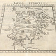
This highly desirable Ruscelli map in trapezoid form is from his work La Geografia di Claudio Tolomeo Alessandrino. Based on the works of Claudius Ptolemy and the atlas of Giacomo Gastaldi, it focuses on the major river systems of the Iberian Peninsula, and on the Pyrenees Mountains, which create a natural border between Spain and France.
The map includes Mauritania, the northwestern portion of Africa on which is located one of the pillars of Hercules. A portion of southwestern France is included. Many cities are denoted and portrayed pictorially, sized according to their population and importance. Islands on all sides of the peninsula are depicted and named.
The Iberian Peninsula has been home to countless civilizations throughout the millennia, from prehistoric times to the present. It was named for the Iberians, one of the early groups settling there, but has also been home to a host of others, including the seagoing Phoenicians, whose most famous colony became the city of Cadiz, the Celts and the Basques in the Pyrenees. Later came the Moors, defeating the Visigoths, settling on the peninsula and ruling it for centuries, their heritage visible in the language, in countless architectural edifices and in customs of the country to this day, despite their being pushed out in the fifteenth century.
Girolamo Ruscelli (1500-1566) was an Italian cartographer, polymath, humanist, editor, and academic active in Venice during the early 16th century. Ruscelli is best known for his important revision of Ptolemy's Geographia, published posthumously in 1574.
Claudius Ptolemy (85-165 CE), a Roman citizen of Greek descent from Alexandria, was the most influential of Greek astronomers and geographers of his time. He propounded the geocentric theory of the solar system which was to prevail for the next 1400 years.
Condition: This map is in A condition. Well-inked plated with some minimal residue and an area of offsetting, otherwise sharp impression. Italian text on the verso.
Inventory #11801
1200 W. 35th Street #425 Chicago, IL 60609 | P: (312) 496 - 3622