


1574 Tabula Asiae III
By: Girolamo Ruscelli
Date: 1574 (published) Venice
Dimensions: 7.25 x 10.25 inches (18.42 x 26.04 cm) plate size
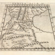
This is a fine example of Ruscelli’s map on trapezoidal projection from his work La Geografia di Claudio Tolomeo Alessandrino. It is based on the work of Ptolemy, and Giacomo Gastaldi, and depicts the region between the The Black Sea and the Caspian Sea, extends into the territory of the Middle East and as far south as Mesopotamia. The map first appeared in the 1561 edition of Ruscelli's edition of Ptolemy's Geografia.
Colchis is in its place on the Black Sea coast, and a large area to the east of Armenia, is labeled Assyriae. Caucasian Albania is in its place to the northwest of the Caspian Sea, with the neighboring Kingdom of Iberia to the west. Centered on present-day Eastern Georgia, it was bordered by Colchis in the west, Caucasian Albania in the east and Armenia in the south. Its population, the Iberians, formed the nucleus of the Kartvelians (i.e. Georgians).
Close to the eastern end of the Caucasus range a defile opens up not far from the shore of the Caspian; this is the Darband pass, called the Gates of Albania and the Caspian Gates by the ancients. Ruscelli has labeled it ‘the Gates of Albania’ along with a vignette of an edifice no doubt intended to represent gates. Cappadocia, which is located in central Turkey is mistakenly shown on the southeastern coast of the Black Sea. The Caucasus Mountains are depicted pictorially and many river systems are denoted. Both seas are stippled. Italian text on the verso describes the areas depicted on the map.
Girolamo Ruscelli (1500-1566) was an Italian cartographer, polymath, humanist and editor, active in Venice during the early 16th century. Ruscelli is best known for his important revision of Ptolemy's Geographia, published posthumously in 1574.
Claudius Ptolemy (85-165 CE), a Roman citizen of Greek descent from Alexandria, was the most influential of Greek astronomers and geographers of his time. He propounded the geocentric theory of the solar system which was to prevail for the next 1400 years.
Giacomo Gastaldi (c.1500-1566) was an Italian astronomer, cartographer and engineer from Villafranca in Piedmont. Many of Ruscelli’s maps are essentially enlarged versions of some of Gastaldi’s maps.
Condition: This map is in A- condition, a crisp, dark impression. A barely perceptible separation in the centerfold.
Inventory #11884
1200 W. 35th Street #425 Chicago, IL 60609 | P: (312) 496 - 3622