Modern Depiction of Portion of Peutinger Map
The Tabula Peutingeriana, or the Peutinger Map as it is commonly called, is one of the most important cartographic artifacts in the history of European map making, one of the few extant maps known to have been drawn in the medieval era. The map was found in 1494 in a library in Worms, Germany, by German Renaissance humanist, scholar, and poet Conrad Celtes, and later bequeathed to Konrad Peutinger, an erudite antiquarian and scholar in Augsburg.
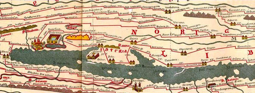
The original parchment roll found in 1494 measured 6.75 meters long, ranging from 32 to 34 centimeters wide. At some point for the sake of conservation, the map was divided into eleven individual leaves, all of which have been preserved in the Vienna National Library since 1738. The map contains voluminous information regarding the vast territories covered by it.
The most defining aspect of this map is its unusual size. The images depicted are too compressed to be a true rendering of the landscape, and its creator did not attempt to depict places and distances at matching scale, nor is the north always at the tope of the map. It has been compared to maps of subways in modern cities which depict how one must travel and the distance between stops.
Long thought to be a copy of a late Roman map, the map is considered by some to be of Medieval origin influenced by Roman prototypes. It is an extraordinary work no matter its origin. This article describes some of its points and features, and presents information regarding scholarly interpretations of the map and its possible origins.
It is commonly thought to be an early 13th century copy of an original map dating to Late Antiquity. Often described as an illustrated itinerarian or Roman road map, the map depicts much of the inhabited world as it was known in antiquity, from the southeast coastline of Britain to the conquests of Alexander in India. It features topographical features including rivers, lakes, oceans, islands, mountains, and forests, with rivers marked in green, mountains in brown, and forests designated by groups of trees. It includes Roman settlements and important cities, of which some are personified, with 555 major and minor cities' names, along with 3,500 other place names, many of which designate relatively small and out of the way places.
One theory of the map which is borne out by its contents is that the original, thought to have been created in the early to mid 4th century, was drawn specifically to depict the great network of Roman roads which totaled 70,000 Roman miles (104,000 km) as well as to depict specific features such as staging posts, spas (of which 52 are noted), harbors, sanctuaries, and distances between points on the map. On the Sinai desert it notes that this was the place where the children of Isreal wandered, along with a number of other biblical references. A quote in Latin in central Asia conveys a message from an oracle to Alexander the Great.
According to J.B Harley and David Woodward in their opus The History of Cartography Volume One, the dating is suggested by the vignettes personifying the cities of Antioch, Rome, and Constantinople. Additionally, it has been suggested that the 4th century tabula may well have been based on a much earlier work, which would account for the cities of Pompeii, Herculaneum, and Oplontis being included, despite their having been destroyed by Vesuvius in its eruption in 79 CE.
The personification of Rome depicts a crowned female figure seated on a throne. She holds a sceptre, a shield, and a globe and is clothed in imperial purple, denoting Rome’s power and prestige. The figure is surrounded by a circle from which twelve main roads radiate, all named, with the great Roman harbor of Ostia depicted below.


