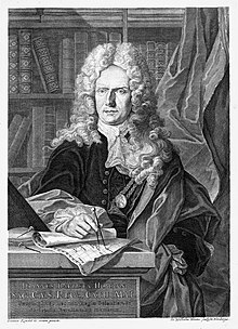
Johann Baptist Homann (1664–1724) was one of the most influential of European cartographers in the late 17th and early 18th centuries. As the founder of the Homann cartographic publishing house, he played a crucial role in establishing Germany as a centre for mapmaking, rivaling the cartographic dominance of France and the Netherlands. His work not only expanded geographic knowledge but also demonstrated the increasing importance of cartography in diplomacy, trade, and scientific inquiry.
Born in1664 in Oberkammlach, Bavaria, Johann Baptist Homann was raised in a Catholic family at a time of significant religious and political tension in the Holy Roman Empire. At the time, the Holy Roman Empire was politically and religiously divided between Catholic and Protestant regions due to the Protestant Reformation, with northern regions tending toward Protestantism, while to the south Catholicism tended to be predominant.
As a young man Homann initially seriously pursued religious studies and joined a Jesuit monastery, suggesting an early intellectual inclination toward an ascetic life, one well grounded in theology and classical education. However, in his early twenties, he was to convert to Protestantism, and left the monastery. It is thought he studied and mastered the art of copperplate engraving in Amsterdam.
His earliest known map is dated 1689 and already shows signs of mastery of his craft. He moved to Nuremberg in the early 1690’s where he worked as a notary, and began to publish maps on a regular basis. He left the city briefly to study copper plate engraving and publishing in Vienna from 1693 - 1695, following which he returned to Nuremberg, where he worked in the map trade, founding his own publishing firm in 1702. The business founded in his name was to thrive for approximately a hundred and fifty years.
During the late 17th century, both France and the Netherlands dominated European cartography, with figures such as Nicolas Sanson, Guillaume Delisle, and Joan Blaeu all producing highly influential maps and atlases. Homann recognized the growing demand for maps within the Holy Roman Empire and sought to create a German alternative to these established cartographic centers.
When he established his own publishing house in Nuremberg in 1702, the city was already known for its printing and scientific advancements. His early works quickly gained recognition for their high quality, detailed engravings, and decorative elements that appealed to royalty, members of the aritstocracy, scholars and the increasingly wealthy bourgeoisie. Homann’s approach combined scientific precision with artistic baroque embellishments, making his maps informative, visually striking, and highly desirable to wide swathes of customers.
The commercial success and longevity of the Homann firm is attributed in part to their tradition of publishing maps which presented not only important, up to date geographic and topographic information, but which made political statements as well. In addition, within the next few years Homann developed a distinctive style of map making, which was characterized by his detailed engraving, an elaborate approach to cartouches that featured classical allegorical vignettes, along with beautiful hand colouring. Another major factor in his success was the lower cost of printing in Nuremberg when compared to the cost in French and Dutch publishing houses.
He was soon publishing his maps in significant numbers, often catering to specific requests and demands of his customers. Homann’s cartographic output was vast, and his publishing house became one of the most prolific and long-lived in Europe. In addition to atlases, Homann created individual maps for specific clients, including members of the Holy Roman Empire’s ruling elite. His works were widely distributed and used for navigation, military strategy, commerce, and governance.
One of Homann’s earliest atlases, Atlas Novus Terrarum Orbis Imperia, dated 1707, features maps of Europe, Asia, Africa, and the Americas. The atlas showcased Homann’s growing reputation for precision as well as his ability to integrate political, economic, and historical data into his maps. Homann’s impact on German cartography proved profound, and in 1715, he was appointed Imperial Geographer by Emperor Charles VI, a prestigious title which underscored his influence in European geographic studies. This position gave him access to state-sponsored surveys and official geographic data, further enhancing the accuracy of his maps. This early (1702) map of Persia exemplifies Homann's style and erudition.

Homann was a product of the Enlightenment, an era that emphasized empirical observation and scientific inquiry. His maps reflect a commitment to accuracy and a reliance on contemporary geographic sources, including the work of astronomers and surveyors. Like his French counterpart Guillaume Delisle, Homann sought to remove mythical and speculative elements from maps, favoring instead verifiable data.
One of Homann’s significant contributions was his use of thematic cartography—maps that focused on specific aspects of geography, such as population distribution, trade routes, or religious affiliations. This approach foreshadowed modern cartographic practices and demonstrated the increasing role of maps as tools for economic and political decision-making. Homann also improved upon the projection techniques used in mapmaking, refining the representation of landmasses to minimize distortion. His maps often included elaborate cartouches—decorative elements that contained explanatory text, allegorical imagery, and coats of arms—further reinforcing their utility as both scientific documents and works of art.
In 1716, Homann published Grosser Atlas über die ganze Welt (Large Atlas of the Whole World). This work, often referred to as the ‘Great Atlas’, secured Homann’s position as the preeminent German cartographer of his era. The atlas contained detailed regional maps of Germany and other parts of Europe, reflecting both geographical knowledge and political boundaries of the time. This Homann map of Russia dates to 1716.

Homann produced a number of influential maps of the New World, including depictions of North and South America that incorporated the latest European geographic knowledge. His work on the Americas often included detailed illustrations of colonial holdings, local peoples, indigenous territories, and natural features. The following maps, Amplissimae Regionis Mississipi, circa 1720, and Virginia Marylandia et Carolina, circa 1714, are representative of his approach.


Johann Baptist Homann played a critical role in transforming German cartography into a powerful force in European mapmaking. His ability to merge scientific rigor with artistic excellence allowed him to produce maps that were both practical and aesthetically remarkable. By emphasizing accuracy, empirical observation, and thematic cartography, Homann helped to shape the trajectory of modern mapmaking. His work remains a testament to the growing importance of maps in the political, economic, and intellectual spheres of the Enlightenment.
After his death in 1724, his cartographic enterprise continued under the name Homann Heirs (Homannische Erben) and remained one of the most significant map publishers in Europe throughout the 18th century and midway through the 19th. His successors built upon his foundation, producing continuously updated atlases and maps, ensuring that his legacy of scientific cartography would continue to contribute to the rapid modernization of cartographic publishing. This magnificent double hemisphere map of the surface of the moon was created by Johann Baptist Homann and Johann Gabriel Doppelmay during Homann's lifetime and was still being published by Homann Heirs in 1742, nearly twenty years following his death.

1 comment
Hi.
I have a original print on rag paper 47cmx57cm of Amplissimae Regionis Mississipi dated 1690 its uncoloured with changes on vinaigrettes and a few additions. Seems to be from the same copper plate size as Homann himself was a engraver .No other original copy have survived or have surfaced so far.Would like to share with you