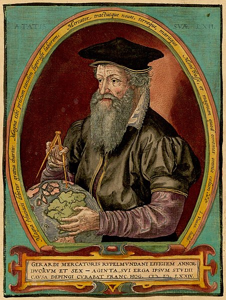
Gerard Mercator (1512 – 1594)
The name Mercator is well known around the world. Most people who know this name associate it with maps, whether or not they actually know who Gerard Mercator was or what his contributions to cartography and science might have been.
Early life and education
Gerard Kremer (Mercator) was born on March 5, 1512, in Rupelmonde, Flanders, where his parents Hubert and Emerentiana Kremer were visiting Hubert’s brother Gisbert, a priest. Gerard’s parents were of low socio-economic status, but Gisbert had studied at the prestigious Louvain University in Flanders and was a priest in Rupelmonde. It was there at the hospice of Saint John that Gerard was born, the youngest of seven children. Some weeks following his birth the family returned to their home in Gangelt.
The first five years of his life were lived in penury as the economy of the area, already in decline, worsened, and finally in 1518 his father gave up trying to make a living in Gangelt and moved his family to Rupelmonde. There the status of Gisbert made it possible for Gerard to enroll in school, where he studied Latin, religion, and arithmetic. A serious and gifted student, in a short time he was able to read, write and speak fluently in Latin.
Within a few years economic conditions in Rupelmonde also deteriorated, and financial stress is thought to have shortened the life of Gerard’s father, who died in 1526, following which Gisbert became Gerard’s legal guardian. Gisbert recognized the intellectual gifts and nascent talents of his nephew and sent him to the Netherlands to study. While there his mother died, and it was at this time that Gerard changed his name. The name ‘Kremer’ means merchant in German but Gerard chose to translate his surname to its Latin version, Mercator, and to use the Latin form of his first name, and thereafter went by Gerardus Mercator de Rupelmonde (Gerard Mercator of Rupelmonde).
In 1530 he matriculated at the University of Louvain, enrolling in courses in the humanities and philosophy. He graduated with the degree of Magister but decided against pursuing a higher degree. His studies had contributed to a philosophical dilemma for him as he found it increasingly difficult to reconcile the philosophy of Aristotle concerning the origins of the universe with the description of its origins in the Bible. His intellectual/philosophical crisis resulted in his turning away from further study at university and in taking to the road, quite literally.
Travel, further studies, early work
On leaving Louvain, he travelled for about two years, visiting both Antwerp and Mechelen. While his travels had little impact on his personal crisis, they did increase his lifelong interest in geography, the study of which he came to see as an endeavor by which he might best explain the structure of the world created by God.
On his return to Louvain in 1534, he undertook the study of mathematics with the renowned Gemma Frisius, but quickly realized that mathematics courses were beyond him. Knowing that Mercator’s goal in studying math was to apply it to cosmography, Frisius tutored him privately, lending him books to study at home. Mercator quickly progressed in his knowledge of mathematics and began to earn a steady living by tutoring university students, while simultaneously applying his knowledge to geography and astronomy. Within a short time he had developed his ideas and necessary skills to the degree that he, Frisius, and another erudite scholar, Gaspard Van der Heyden, undertook to construct a terrestrial globe commissioned by Emperor Charles V. The globe was constructed in 1535-1536, and the strips of paper used to construct this globe were among the first to have been engraved on copper plates rather than wood. Due to the fineness of print allowed by copperplate engraving the globe contained a vast amount of information which had been impossible to include using woodcuts. The use of copper plates was an enormous leap forward for cartography and bookmaking.
Marriage, professional development, arrest and release
Mercator married Barbara Schellekens in September of 1536, and within a year the first of six children was born to him and his wife. Family life did not dampen his eagerness to work in cartography and in 1537 he once again worked with Frisius and Van der Heyden to construct another globe, this one of the stars. This second globe put him in an enviable position, for he became acquainted with or known to the intelligentsia of his day, including professors, rich merchants, prelates, aristocrats and courtiers of the emperor Charles V in Brussels. The commissions and patronage of such individuals would contribute to his financial well-being throughout his life.
The same year Gerard produced his first map, of Palestine, a territory which he felt he knew as well as his own immediate environs due to his years of religious study. His first map of the world, dated 1538, used the projection developed by French mathematician/cartographer Oronce Fine. It was the first known map to represent both North and South America, and Mercator is credited with having given North America its name. In 1539 he mapped Flanders and a short time later, made another globe. His globes came to be in great demand, and he produced so many of them that several are extant today. He was also interested in the style of script used for commentaries to maps, and published a book, Literarum Latinarum, dedicated to the italic script which he developed and which is still in use today.
Mercator continued to increase and hone his cartographic skills, and did an enormous amount of local travelling in order to obtain information from explorers and people close to them. Information regarding the previously unknown, virtually unexplored continents was changing so rapidly that maps were often obsolete by the time they were published. He had long had in mind publishing a new map of the world by first publishing maps of each region, but in February of 1544 during the religious unrest (Inquisition) in western Europe, his travels were interrupted, and were in part responsible for his being arrested, charged with heresy, and thrown into prison in Rupelmonde along with a number of other scholar ‘heretics’. Though Mercator’s house was searched and his belongings confiscated, there was nothing incriminating found and he was released, as nothing showed him to be anything other than a good Roman Catholic. Some of those arrested stated that they did not believe the body of Christ to be physically present during communion rites and did not believe in purgatory. They were burned at the stake or buried alive.
On his release Mercator found himself in difficult financial circumstances, and he began to make mathematical instruments as he had learned from Frisius, including astrolabes and astronomical rings used to study the geometry of astronomy and astrology. In 1552 he moved his family to Duisberg, where plans had been announced to build a university, which he knew would increase the demand for maps, books, globes and mathematical instruments. He opened his own business there, and by 1554, after publishing a large map of Europe, he was financially secure enough to purchase a large new home in the wealthiest neighborhood of Duisberg.
Final decades 1554 - 1594
Mercator lived a long life, 82 years to be precise. By 1554 he had published many maps, and was soon to be named Court Cosmographer. His financial success allowed him to investigate and work on myriad projects such as his Chronologia, a list of all significant events since the beginning of the world. This was compiled from his own reading of the Bible along with the works of authors or genealogies and histories of all the empires known to him to have existed. It was met with great enthusiasm. Surprisingly, his atlas (he was the first to use this term for a collection of maps in book form) was not as successful as one might expect, and he is probably best known for the 'Mercator projection' that bears his name, which was first used by him in 1569 for a wall map of the world on 18 separate sheets.
The 'Mercator projection' has the property that lines of longitude, latitude and rhomb lines all appeared as straight lines on the map. If you have ever seen a map of the world in a classroom or in an atlas, chances are you have seen the Mercator projection, a geographical chart where the spherical globe is flattened into a two-dimensional map, with latitude and longitude lines drawn in a straight grid. Mercator’s view of the world is one that has endured through the centuries and still helps navigators today. Indeed, the world as viewed from a cartographic perspective today owes much to how it was mapped early on in the work of the brilliant cartographer extraordinaire, Gerardus Mercator de Rupelmonde, the ‘Merchant of Rupelmonde’.
1 comment
NOT tvw2