In 2008, a stunning map was found in the basement of one of the world’s most famous libraries, Oxford University’s Bodlean. This map, the Selden Map of China dated to circa 1609, is thought to be one of the first maps of Chinese origin and authorship to make its way to western Europe, and is one of the earliest known surviving Chinese maps made for maritime merchants. The map is a serious and stunning work of art, drawn in blank ink on large sheets of paper glued together to create an enormous chart which was probably intended for hanging on a wall.
A holding of the Bodleian Library of Oxford since 1659, the map is named for London lawyer John Selden, who bequeathed it to the library. Documents indicate that Selden was already in possession of the map by 1653, as it is mentioned in a codicil to his will dated that year in which he noted that the map had been acquired through an Englishman – a commander as noted by Selden.
Following the map’s arrival at the Bodleian Library, it was studied and annotated in Latin in 1687 by librarian Thomas Hyde. As the map’s inscriptions, detail cities, ports and Asian countries are all in Chinese, Hyde was most fortunate to have the assistance of Chinese Jesuit convert Michael Shen Fuzong, an early visitor from the Orient to western Europe who had arrived at the royal court of James II from China, making stops along the way in various European cities and courts. James was so fond of this Chinese Jesuit that he commissioned a painting of him.

Michael Shen Fuzong
The map lived a quiet life at the Bodleian, attracting little interest despite being kept on permanent display due to its unusual size and its unique style and beauty. Measuring 62.2 inches in length and 37.8 inches in width, the map is too big for practical use as a navigational chart on board a seagoing vessel, and probably served a decorative function instead, perhaps adorning the wall of a wealthy merchant’s house. The map was accorded little attention until 2008 when it was ‘rediscovered’ by academic Robert Batchelor, who discerned in it features which distinguish it from virtually all other known maps of China. Aside from its beauty as a work of art, and its unusual size, the map presents numerous unusual elements and puzzles.
Among the most important aspects of the map are its carefully drawn shipping routes ranging from Nagasaki down to Aceh in Sumatra, along with an inscription which explains how to navigate to the Persian Gulf and Red Sea. Though much of this information had been recorded in antiquity in various sources such as the Periplus of the Erythraean Sea, much had been or was thought to have been lost. The appearance of the Selden Map suggests that the knowledge had continued to be accessible, and used in places other than western Europe.
The Selden Chart is centered on the Sea rather than land, marking a break with the long-held tradition of China being the centre of the known world. The map is oriented north. Southeast Asia is shown with its centre as Ming China, extending from the Indian Ocean in the west to the Spice Islands in the east. Japan is to the north and Java to the south.
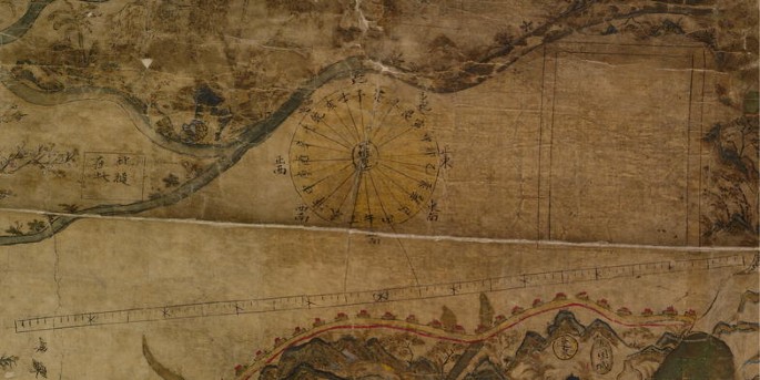
Some aspects of the map which are unusual and immediately draw the eye include a scale-bar and a European style compass rose, neither of which is known to have been used on earlier Chinese maps. While their use has not been found in earlier extant maps, their presence in the Selden Map signal a deep, thorough knowledge of Western mapmaking traditions in China.
Bejing and the Great Wall, the Yellow River and provincial boundaries are all present in the map. While much of the wall was constructed during the Ming Dynasty, its earliest traces date to the 7th century BCE. In the approximate middle of the western edge of the Indian subcontinent the port city of Calicut is depicted. While the Bay of Bengal is not depicted, notes describe how to sail from Calicut to destinations such as Yemen, Oman and Hormuz, suggesting the cartographer’s knowledge of and familiarity with the early 15th century voyages made by Chinese Admiral Zheng He.
Both the Moluccas in eastern and Sumatra in western Indonesia are depicted in detail, revealing their importance as strategic maritime locations. The lush, tropical islands of the Moluccas, located at the confluence of a series of maritime trade routes had already been central to maritime commerce and the economy of the region long before this map was drawn. Sumatra’s pivotal location is at the westernmost point of trading routes across the South China Sea, which also serves as the entrance to the Indian Ocean and was long the source of fierce rivalry involving the Dutch, Portuguese and English regarding control of the fabulous wealth-creating spice trade of the time.
Though the centre of southeast Asia begins in Ming China, the chart is centered on the Sea rather than land, marking a break with the long-held tradition of China being the centre of the known world, and most often being represented as such in charts and maps. The artistry of the map is worthy of attention as the author took pains to include even flora and fauna in many regions.
The time period to which creation of the map can be attributed was during the late Ming period, probably during the reign of Zhu Yijun (personal name), also known as Emperor Zhernzong, the Hanli Emperor, who ruled from 1563-1620. The Ming Dynasty ruled China from 1368 – 1644 CE, during which time its population is thought to have doubled. Other notable Ming achievements include the restoration and refurbishment of the Great Wall to its greatest glory, large naval expeditions, vibrant maritime trade, and the rise of a heavily monetized economy.
The Selden Map is noteworthy as a product of Chinese cartography for revealing the increase in maritime trade and global commerce rather than focusing on local Chinese commerce. In addition to its contribution to globalization of that era, the Ming Dynasty also contributed much to the development of the arts in general including drama, literature, graphic arts and its world-renowned fine porcelain. Politically, the Dynasty is known for having expanded its trade to much of the rest of the world, including establishing cultural and trade ties with the West.
Selden Map Compass Rose and Distance Scale